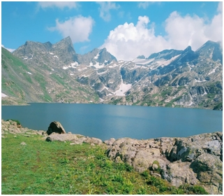
 High above the familiar valleys of Kashmir, where the mountains seem to touch the sky, lies Krishansar Lake, a beautiful mountain lake situated at an altitude of more than 3,700 metres in Ganderbal district. Surrounded by rocky slopes, green meadows and towering peaks, the lake is one of the most attractive destinations along the famous Kashmir Great Lakes trekking route. Its clear waters reflect the mountains above, changing from deep blue to green as the sunlight moves across the sky. During summer, trekkers reach the lake after walking for hours along rocky paths and grassy slopes. Many sits beside the water, enjoy the cool mountain breeze and take photographs of the breathtaking scenery. The silence is so deep that even the gentle movement of water feels special. For many visitors, Krishansar is the end of a difficult but rewarding walk. Yet the lake has another story to tell, one that begins when its waters leave the shore and travel towards distant valleys. Looking at the lake, it is difficult to imagine how far its water will travel and how many landscapes it will touch before continuing its journey beyond the mountains. What appears to be a peaceful body of water is connected to a much wider natural system that supports life far below.
The Kishanganga river system draws water from a network of mountain streams, rainfall, melting snow and seasonal runoff. The catchment around Krishansar Lake forms an important part of this high-altitude landscape, while streams from the Dras side also contribute to the wider network. Among the locally known channels are Kaobal Gali Nala, Sire Gah Nala, Gotum Shing Nala and Knari Gah Nala, sometimes referred to together as the Chakwali Quartet. These names are more than simple labels on a map. They reflect the knowledge of local people who have observed the mountains, followed the streams and understood their seasonal changes over generations. The exact meeting points of these channels and the identification of the river’s main source require confirmation from detailed topographic maps and hydrological records. As the snow melts in warmer months, small streams grow stronger, rushing over stones and cutting through narrow mountain channels. During colder periods, their flow may decrease as temperatures fall and water freezes at higher elevations. The wider headwater landscape is also associated with neighbouringVishansar Lake and streams draining the surrounding ridges. In these mountains, water rarely moves gently for long. It tumbles down steep slopes, passes through rocky gaps and gathers strength as other streams join its course. The land itself tells the story of this movement, with deep channels and uneven slopes shaped over centuries by flowing water, glaciers and erosion. Every bend reveals another part of the mountain world, where nature works quietly but continuously to shape the landscape.
“A river begins as a whisper in the mountains, gathers the stories of the valleys, and carries the memory of the land wherever its waters flow.”
As the river moves through the highlands, the surroundings gradually change. Bare rocky slopes give way to greener valleys, patches of forest and open meadows. The air becomes different, the settlements become more visible, and the sound of flowing water begins to blend with the rhythm of village life. The journey leads towards Tulail and then Gurez, two beautiful areas where the mountains stand like guardians over the Kishanganga. Here, the river is not simply something to admire from a distance. It is part of the landscape in which people live, work and carry out their daily activities. In Gurez, situated in Bandipora district, traditional wooden houses and stone structures stand beneath towering mountains, while grassy meadows stretch along the water. The valley has a distinct character shaped by its geography, history and long periods of isolation. Its natural beauty is matched by the resilience of the people who have adapted to the demands of mountain life. Winter brings heavy snowfall, often making travel difficult and leaving the road across Razdan Pass closed for extended periods. During these months, the valley can become difficult to reach from the rest of Kashmir. With the arrival of summer, the snow gradually retreats, the road reopens when conditions permit, and life becomes easier for residents and visitors alike. Travellers return to explore the valley, enjoy its peaceful surroundings and discover a side of Kashmir that feels different from its more frequently visited destinations. For anyone following the Kishanganga, Gurez offers a chance to understand the close relationship between a river and the people living beside it. The water passes through meadows and villages, continuing its journey while remaining deeply connected to the everyday life of the valley.
The Kishanganga’s journey does not end in Gurez. The river continues towards the Line of Control and enters Pakistan occupied Kashmir, where it is known as the Neelum River. From Gurez and Tulail in northern Jammu and Kashmir, the Kishanganga flows on for roughly 245 kilometres before joining the Jhelum near Muzaffarabad. It nourishes freshwater habitats and the communities that depend on them, and it forms part of the wider Indus basin. After crossing the Line of Control, it takes the name Neelum. Figures often cited divide this distance into around 50 kilometres on the Indian side of the Line of Control and approximately 195 kilometres on the other side. These measurements may vary depending on how the river’s course is traced and measured, but they offer a sense of the distance covered by its waters across different landscapes. A river that begins among the high mountains of Kashmir eventually becomes part of a much longer geographical story, connecting valleys that are separated by a political boundary but remain linked by the natural movement of water. Standing beside the Kishanganga in Gurez, one can watch the current moving between the mountains and imagine the places it will reach beyond the visible horizon. The river does not recognise the lines drawn on maps. It follows the slope of the land, carries water from one valley to another and continues along the course shaped by nature. Its journey reminds us that Kashmir’s mountains are not merely scenic landmarks but living landscapes where lakes, glaciers, forests, streams and rivers form a connected world. For travellers, following the Kishanganga is more than a journey through beautiful places. It is an opportunity to experience the changing face of Kashmir, from the still waters of Krishansar to the green meadows of Tulail and the welcoming valley of Gurez. Every bend in the river offers a fresh view, and every stretch reveals another story of nature, human life and the enduring bond between water and the land
sheikhnazirmehdi@gmail.com